
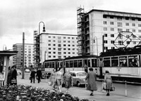
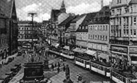
Chemnitz Main Railroad Station was the first destination in the city to be served by the horse tram, which opened 1880. This was also the first destination to receive the electric tram service in 1893.
( 1910 , Postcard )

Eigenbau / Poger Elektrizitats-AG
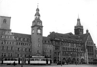
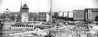
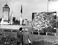
The Main Railroad Station is located somewhat outside of the city center. Even though most of Chemnitz was destroyed in the World War II, this area has escaped most of the bombings - the square in front of the Station looks almost the same today, as it did at the time of this photo.
( 1934 , Postcard )

Tatra T3DM+T3DM+B3DM, Bombardier Variobahn 6NGT-LDE
The Main Railroad Station Loop is a double-track installation that encircles a sizeable city block. At the time of this photo the inner loop track was used by Line 4 operating clockwise (tram pictured on the left), while the outer loop track was used by joint-service Lines 6 and 522 operating counterclockwise (tram pictured on the right). This way each service had its own track for layovers at the terminal. Trains in this photo are awaiting their respective departure times.
( 26.08.2008 , Yury Maller )

Tatra T3DM+T3DM+B3DM
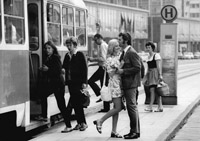
City-bound train serving Line 4 departs the Hauptbahnhof Terminal. At the time of this photo there were 28 Tatra T3DM motor cars and 10 Tatra B3DM trailer cars still in operation, even though there were already 24 low-floor trams available, with only 22 of those needed to maintain service. Thus, technically speaking, Chemnitz could have already made service without high-floor cars. Nevertheless, on the day in question 7 2-car and 3-car Tatra trains did operate in service, working Lines 2, 4 and 5. Tatra cars operated on weekdays only.
( 26.08.2008 , Yury Maller )

Tatra T3DM+T3DM+B3DM
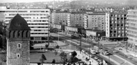
Carolastrasse is the southern approach to the Main Railroad Station. The tram terminal at the Station became a one-way loop upon it's re-gauging from 925 mm to 1435 mm in 1967. It was, however, double-tracked shortly before this photo was taken. The grand Theaterplatz (ex-Adolf-Hitler-Platz) in the background happens to be next to the only photo-op in modern Chemnitz featuring buildings of historic architectural significance.
( 26.08.2008 , Yury Maller )

Bombardier Variobahn 6NGT-LDZ, Duo-Voltage
Duo-voltage tram serving suburban Line 522 is seen on the final approach to the Main Railroad Terminal. Line 522 connects Chemnitz and the town of Stollberg, 20 km. southwest of the city. It utilizes the tram network within the city, electrified at 600 volts, and uses Deutsche Bahn tracks outside of the city, electrified at 750 volts. Line 522 operates on the joint timetable with Line 6, the latter being the short-turn city-only version of the former. Line 522 is operated by the City-Bahn suburban operator, with trams painted red. Line 6 is operated by the CVAG city operator, with trams mostly painted blue or orange.
( 26.08.2008 , Yury Maller )

Tatra T3DM+T3DM
The northern approach to the Main Railroad Station is pictured here at the time when the terminal loop was still a single-track, with all services operating counterclockwise. At the time of this photo the 2nd track on the right was not used, and ended with stub end further up the street.
( 28.06.2006 , Wikipedia )

Bautzen / AEG
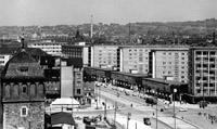
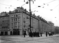
DDR-era signature concrete boxes on the eastern side of Theaterplatz. The building on the right is the Moscow Hotel. This photo was taken prior to the re-gauging (and the temporary closure) of the Main Railroad Station branch between 1963 – 1967, thus the featured tram is shown operating on the old 925 mm track.
( 06.09.1962 , Deutsches Bundesarchiv )

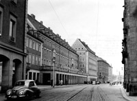
The old Konigstrasse, the main thoroughfare connecting the city center and the Main Railroad Station, the way it looked at the beginning of the XXth century, before it was demolished in the World War II - looking north, toward the Station.
( 1917 , Postcard )

Tatra T3DM+T3DM+B3DM
The new post-WWII and post-DDR version of the former Konigstrasse, nowadays Strasse der Nationen - looking north, toward the Station.
( 26.08.2008 , Yury Maller )

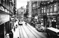
The old Konigstrasse the way it looked at the beginning of the XXth century, before it was demolished in the World War II - looking south, toward the city center. The former major Johannisplatz tramway junction is seen in the background. The junction has now migrated to the modern intersection of Strasse der Nationen / Bruckenstrasse, nowadays located approximately at the point where this photo was taken from.
( 1911 , Postcard )

Tatra T3DM+T3DM+B3DM
The new post-WWII and post-DDR version of the former Konigstrasse, nowadays Strasse der Nationen - looking south, toward the city center. The former major Johannisplatz tramway junction used to be located approximately at the far end of the DDR-era apartment building on the left.
( 26.08.2008 , Yury Maller )
Bautzen / AEG + Christoph & Unmack, Niesky
The signature DDR-era apartment boxes have replaced the old grand buildings along Konigstrasse, demolished in the World War II. In this photo the apartment complex is still being built. This photo was taken prior to the re-gauging (and the temporary closure) of the Main Railroad Station branch between 1963 – 1967, thus the featured tram is shown operating on the old 925 mm track.
( 24.08.1961 , Deutsches Bundesarchiv )

Bautzen / SSW
( 01.12.1962 , Deutsches Bundesarchiv )
The photo is taken during the reconstruction and re-gauging of the Main Railroad Station tramway line via Strasse der Nationen.
( 17.06.1965 , Deutsches Bundesarchiv )
Tatra T3D+T3D+B3D
This photo was taken after the re-gauging (widening) of the Main Railroad Station branch was completed in 1967, thus the featured tram operates on the new 1435 mm tracks.
( 23.07.1975 , Deutsches Bundesarchiv )

Tatra T3D+T3D+B3D
( 19.05.1979 , Deutsches Bundesarchiv )

Bombardier Variobahn 6NGT-LDE
This new major tramway junction replaced the former Johannisplatz junction, demolished during the World War II. The junction has migrated one city block north of the former location.
( 26.08.2008 , Yury Maller )

Bombardier Variobahn 6NGT-LDZ
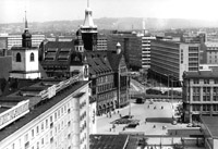
Tram traverses the vast emptiness of the huge square in the heart of the once-densely build up Chemnitz city center - a site sadly emblematic of the modern post-WWII and post-DDR Chemnitz.
( 26.08.2008 , Yury Maller )

Tatra T3D+T3D+B3D
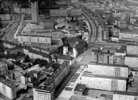
This new vast square was built by the DDR in place of the formerly densely build up Chemnitz city center, demolished in the World War II.
( 03.06.1977 , Deutsches Bundesarchiv )
Tatra T3D
( 08.07.1972 , Deutsches Bundesarchiv )

Tatra T3DM+T3DM
Tram station in the middle of square in the heart of the city center. At the time of this photo Tatra trams were used on Lines 2, 4 and 5. While 3-car Tatra trains operated on Lines 4 and 5, Line 2 was served with 2-car trains. Note, that all three lines were nevertheless also served with low-floor cars of the same standard length. High-floor and low-floor trams serving the same lines were alternated, so the low-floor feature would be provided with at least each 2nd tram.
( 26.08.2008 , Yury Maller )

MAN Diesel Bus
Chemnitz has lost most of its tram network to the re-gauging campaign of the 1950-80s, which was meant to widen the entire network from 925 mm to 1435 mm. In line with the DDR-era best practices, this project was never fully realized, with 60% of the network having closed instead - the re-gauging of most lines was officially deemed economically unfeasible. Consecutively, Chemnitz ended up being the only Eastern German city with trams, where more than half of the passengers are carried by diesel buses.
( 26.08.2008 , Yury Maller )

Tatra T3DM+T3DM
Chemnitz's central-most tramway line near Markt is turned into a tram-pedestrian mall. The location shown in this photo is the exact site of the former Johannisplatz tramway junction, demolished during the World War II.
( 26.08.2008 , Yury Maller )

Trams operated through Chemnitz's main square between 1893 and 1988. Nowadays trams briefly appear in the southeastern corner (the far left corner in this photo) of the square.
( 1904 , Postcard )
Bautzen / AEG + Bautzen; Niesky
Chemnitz's main city square during the heyday of tram operation.
( 1920s , Postcard )
Bautzen / AEG + Bautzen; Niesky
Chemnitz's main city square after the World War II. The Rathaus is the only building within the square that survived the war.
( 07.05.1953 , Deutsches Bundesarchiv )
Tatra T3D+T3D
Chemnitz's main city square was completely redesigned under the DDR. Old buildings that were demolished during the World War II are now replaced with DDR's signature concrete boxes. A Tatra tram is pictured leaving the Central Stop toward the Main Railroad Station.
( 03.05.1983 , Deutsches Bundesarchiv )
The old historic Chemnitz's city center the way it looked under the DDR. Socialist-style super blocks completely replaced the old street grid.
( 31.03.1977 , Deutsches Bundesarchiv )
This post-World War II photo still captures the former Klosterstrasse line that extended northward from Markt. The line was relocated to the newly-cut Ernst-Thelmann-Str. in the early 1960s.
( 03.04.1956 , Deutsches Bundesarchiv )

Bombardier Variobahn 6NGT-LDZ
This is as close as trams now get to the city's main square, visible in the background of this photo. The entire area is a tram-pedestrian mall, dominated by the modern shopping gallerias. Only episodic old buildings remain in the square.
( 26.08.2008 , Yury Maller )
Bautzen / AEG
The old Kronenstrasse the way it looked in the first half of the XX century. The entire street will be destroyed during the World War II. It is currently a site of the modern Am Rathaus and the new Zentralhaltestelle complex.
( 1930s , www.historisches-chemnitz.de )
Bombardier Variobahn 6NGT-LDZ
The Zentralhaltestelle complex the way it looked during the DDR years.
( 03.05.1983 , Deutsches Bundesarchiv )

Bombardier Variobahn 6NGT-LDZ
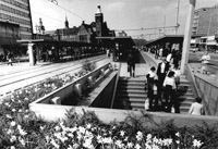
The north-south platforms of the new overwhelming XIX century version of the Zentralhaltestelle (the Central Stop) complex. The east-west platforms are located on Bahnhofstrasse, to the right.
( 26.08.2008 , Yury Maller )

Bombardier Variobahn 6NGT-LDZ
At the time of this photo Line 2 served all 4 platforms at the Zentralhaltestelle, as it followed the main city center loop in both direction, thus passing through the complex twice in each direction.
( 26.08.2008 , Yury Maller )

Bombardier Variobahn 6NGT-LDZ, Duo-Voltage
Duo-voltage tram serving City-Bahn-operated Line 522 departs the Central Stop and heads toward the suburban city of Stollberg. Line 522 utilizes the tram network within the city, but switches to the Deutsche Bahn tracks in the suburbs.
( 26.08.2008 , Yury Maller )

Bombardier Variobahn 6NGT-LDE
The east-west platforms of the Zentralhaltestelle (the Central Stop) complex. The north-south platforms are located on Am Rathhaus, to the left.
( 26.08.2008 , Yury Maller )

Tatra T3DM+T3DM+B3DM
Train crosses the largest tramway junction in modern Chemnitz - essentially a grand union, minus one move.
( 26.08.2008 , Yury Maller )

Bautzen / AEG + Christoph & Unmack, Niesky
The line via Otto-Grotewohl-Str. [Bahnhofstrasse] acts as a belt line around the southern perimeter of the city center. The 915 mm (later 925 mm) track was in service ever since the introduction of the horse tram in 1880. The line was re-gauged in 1976. This photo was taken prior to the re-gauging, thus the featured tram is shown operating on the old 925 mm track.
( 27.03.1968 , Strassenbahnen in Osteuropa )

Bautzen / AEG + Christoph & Unmack, Niesky
This photo was taken prior to the re-gauging of the Otto-Grotewohl-Str. [Bahnhofstrasse] line in 1976, and prior to closure of the northern lines to Sonnenberg, Hilbersdorf and Elbersdorf in 1972-1976. The tram in this photo operates on the old 925 mm track via the now-extinct Line 8 to Elbersdorf.
( 12.10.1969 , Strassenbahnen in Osteuropa )

Tatra T3DM+T3DM+B3DM
The western section of Bahnhofstrasse was re-gauged to the standard 1435 mm in 1988. It was a part of the 925 mm loop around the city center that remained in service until the last narrow-gauge line was closed. The street leading to the right was the original site of the old Konenstrasse, and the former tramway link to Markt. The line now migrated slightly to the east, to the modern Am Rathaus.
( 26.08.2008 , Yury Maller )

Bombardier Variobahn 6NGT-LDZ, Duo-Voltage
Duo-voltage suburban tram returns from Stollberg.
( 26.08.2008 , Yury Maller )

Tatra T3DM+T3DM+B3DM
Tram lines in the modern Chemnitz' city center are mostly wide reserved right-of-ways built over vast open spaces that became available upon the distraction of the original buildings during the World War II.
( 26.08.2008 , Yury Maller )

The former principal tramway junction, the old Johannisplatz, the way it looked at the beginning of the XXth century, before it was demolished in the World War II - looking south. The featured tramline runs down Poststrasse. This is the belt line around the southern perimeter of the city center, and the very first tramline to open in the city, operating in horse mode since 1880, and electrified in 1893.
( 1910 , Postcard )

Eigenbau / Poger Elektrizitats-AG
The former principal tramway junction, the old Johannisplatz, the way it looked at the beginning of the XXth century, before it was demolished in the World War II - looking north. The entire square was demolished, and has now succumbed to the new city street grid, developed under the DDR.
( 1910s , www.historisches-chemnitz.de )

Düsseldorf / AEG; Bautzen / AEG + Bautzen; Niesky
The former principal tramway junction, the old Johannisplatz, during the heyday of tramway operation - looking south.
( 1930s , www.historisches-chemnitz.de )

Tatra T3DM+T3DM+B3DM
A wide reserved tramway right-of-way cuts through the empty lot located in place of the former Johannisplatz. The only remaining reminder of the former grand square is the oddly aligned building on the right, in the back, behind the pictured tram - the building's positioning reflects the geometry of the former Johannisplatz.
( 26.08.2008 , Yury Maller )

Düsseldorf / AEG; Bautzen / AEG + Bautzen; Niesky
The overview of the former principal tramway junction, the old Johannisplatz, pictured during the heyday of tramway operation - looking north. The intersection with the former Konigstrasse (nowadays Strasse der Nationen) is in the front - tracks to the left lead to Hauptbahnhof, while tracks to the right lead to Markt. In the back of the square the line to Gablenz, Hildersdorf and Ebersdorf diverges to the left, while the belt line around the city center via Poststrasse veers to the right.
( 1935 , Postcard )
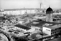
The former Johannisplatz is reduced to the vast open field (beyond the tower). The post-World War II remains of the square are bulldozed to make way for the new DDR-style super blocks.
( 06.10.1964 , Deutsches Bundesarchiv )

Bombardier Variobahn 6NGT-LDZ
This modern stretch of track on Bruckenstrasse replaced the former old tram link between Poststrasse (nowadays Bahnhofstrasse) and Konistrasse (nowadays Strasse der Nationen) through the former Johannisplatz.
( 26.08.2008 , Yury Maller )

Düsseldorf / AEG + Bautzen; Niesky
A closer take at the former Johannisplatz / Konigstrasse junction in the northern end of Johannisplatz, the former Chemnitz's principal tramway junction.
( 1920/30s , www.historisches-chemnitz.de )

Bautzen / AEG + Bautzen; Niesky
The former principal tramway junction, the old Johannisplatz, during the heyday of tramway operation - looking north. The former Jahannisplatz / Konigstrasse junction at the southern end of the square is in the forefront.
( 1920/30s , www.historisches-chemnitz.de )
Bautzen / AEG + Bautzen; Niesky
The former Jahannisplatz / Konigstrasse tramway junction still exists, while the city around it is reduced to an opened field. The post-World War II remains of the old buildings are bulldozed to make way for the new DDR-style super blocks.
( 03.05.1963 , Deutsches Bundesarchiv )

Bombardier Variobahn 6NGT-LDE
Tram at the junction with the Altchemnitz Line.
( 26.08.2008 , Yury Maller )

Eigenbau / Poger Elektrizitats-AG
The old Falkeplatz the way it looked at the beginning of the XXth century, before it was demolished in the World War II - looking eastward, toward the city center. The Theaterstrasse Line branches off to the left, while the Poststrasse Line branches off to the right. Tracks continuing straight ahead lead to Markt via the circuitous corridor through Rossmarkt and Holzmarkt, which existed 1900-1953.
( 1920s , Postcard )

Bautzen / AEG + Bautzen; Niesky
Modern DDR-era apartment buildings and wide boulevards replaced the old buildings and the former street grid around Falkepltaz, demolished during the World War II.
( 07.11.1964 , Deutsches Bundesarchiv )

Bautzen / AEG + Bautzen; Niesky
The old Theaterstrasse the way it looked at the beginning of the XXth century, before it was demolished in the World War II. The line was opened as a 915 mm (which later became 925 mm) horse track in 1880 and lasted until 1988 (even though realigned in the 1960s), when the last narrow-gauge tramline in the city was closed.
( 1920/30s , Postcard )

Bautzen / AEG
Tram at the junction between the former Theaterstrasse Line and the former Weststrasse Line. The single car is turning toward Weststrasse operating via Line 8. The new 925 mm track alignment is seeing on the right side of the street, while the featured tram is still operating on the old tracks. The Weststrasse Line will close in 1983, while the new alignmnet on Theaterstrasse will become the last narrow-gauge line to go, and will close in 1988.
( 29.09.1962 , Deutsches Bundesarchiv )

Bautzen / AEG + Bautzen
Tram at the junction of the former Theaterstrasse Line, that acted as the belt line around the northern perimeter of the city center, and the former Rottluff and Borna Lines, branching off to the right. Tracks to the left lead to Markt via Inne Klosterstrasse.
( 14.09.1960 , Deutsches Bundesarchiv )

Junction between the former Theaterstrasse Line and the former Rottluff and Borna Lines, the way it looked at the beginning of the XXth century - looking east. The featured tram is Markt-bound and has just returned from either Rottluff or Borna.
( 1915 , Postcard )

Eigenbau / Poger Elektrizitats-AG
Junction between the former Theaterstrasse Line and the former Rottluff and Borna Lines, the way it looked at the beginning of the XXth century - looking west. The line to the left went to Markt.
( 1910s , Postcard )

Düsseldorf / AEG + Bautzen; Niesky
Junction between the former Theaterstrasse Line and the former Rottluff and Borna Lines, the way it looked before the surrounding area was demolished in the World War II. The tram on the left is probably Weststrasse-bound, while the tram on the right is Furth-bound.
( 1931 , Postcard )
Junction between the former Theaterstrasse Line and the former Rottluff and Borna Lines, the way it looked after the World War II. The track layout in this photo still reflects the old pre-war alignment, even though the city around it was demolished in the World Ward II, and the new buildings were built instead. 7 years later the junction will be moved to the new Hartmannstrasse, which will be cut through the old street grid some 200 m east of here.
( 03.04.1956 , Deutsches Bundesarchiv )
Bautzen / AEG + Bautzen; Niesky
The new junction between the former Theaterstrasse - Furth Line (going straight) and the former Rottluff and Borna Lines (branching off to the left) opened in 1963, when the new Hartmannstrasse was cut through the old street grid. The old junction existed some 200 m. west of here. The new junction will be closed, in turn, in 1983, upon the removal of the last 925 mm. line in the city. The old pre-war neighborhood was completely built over with new DDR-style concrete super-blocks.
( 21.11.1966 , Deutsches Bundesarchiv )
The former section of the Theaterstrasse belt line between Johannisplatz and Klosterstrasse. This photo was made on the very day of the official closure of the line. The overhead is already removed. The street itself would soon be demolished to make way for the new city hall.
( 01.11.1963 , Deutsches Bundesarchiv )
( 12.09.1961 , Deutsches Bundesarchiv )