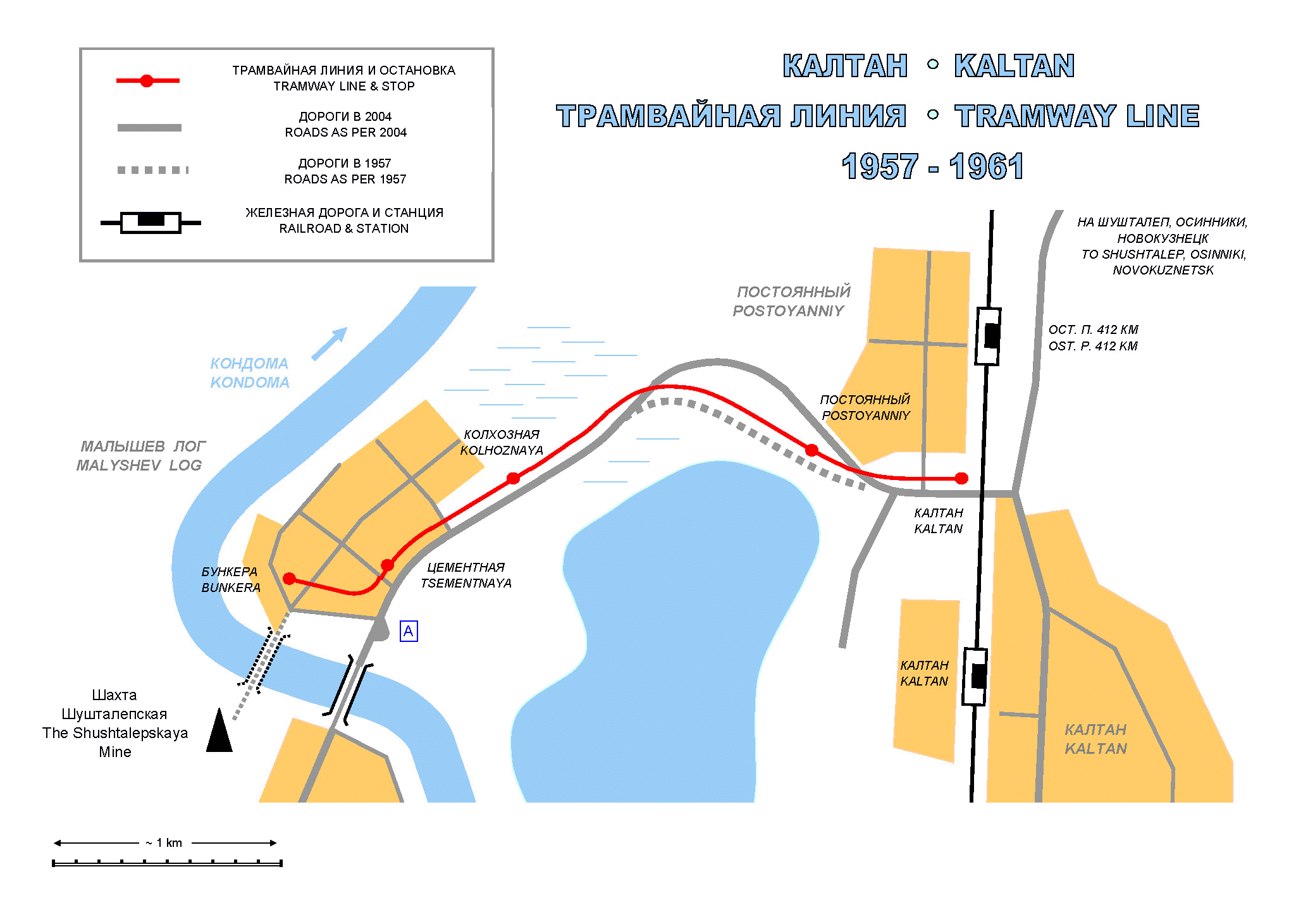


[ World ] [ Russia ] [ Kaltan ] [ Facts ]
|
01. The railroad crossing between the Platforma 412 Km. and Kaltan stations. This point was the Kaltan terminal of the tramway line to Malyshev Log. The Kaltan town boundary is just across the tracks, to the right. (09.09.2004, YM) |
|
02. About 100-200 meters passed the railroad crossing, the modern road curves to the right, toward the Postoyanniy town line, while the old road and the tramway track continued slightly to the left. The former roadbed could still be visible, leading into the bushes right behind the pole in this photo. The tramway track used to be to the left of yellowish bushes, between the old and the new roads. The Postoyanniy tramway stop was located right behind those yellow bushes. (09.09.2004, YM) |
|
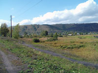
03. The road to Malyshev Log with roofs of the village itself in the background. The tramway line followed the northwestern side of the road (viewer's right), through the marshes. This photo is made between the Postoyanniy and Kolkhoznaya stops. (09.09.2004, YM) |
|
04. The western side of the road upon the approach to Malyshev Log, near the Kolkhoznaya stop. The tramway line used to follow the pedestrian path over the remains of the former trackbed, still visible after all these years. (09.09.2004, YM) |
|
05. The Malyshev Log tramway terminal point, known as the Bunkera stop, near the Kondoma River, next to the northern end of the Vozdushniy (Air) coal/pedestrian bridge. Mine's workers disembarked here and continued over the bridge on foot. The tramway stop used to be a village center. The former post office was located right next to the stop, to the vewer's left. (09.09.2004, YM) |
|
06. The actual remains of the Kaltan - Malyshev Log tramway, the trackbed of the former railroad-turned-tramway line near the terminal point, the Bunkera stop. The trackbed is covered with weeds, but it is clearly visible, marked out by the fence curving right over it. The stop was located exactly at the point where the fence in this photo crosses the trackbed. (09.09.2004, YM) |
|
07. The former trackbed became an artificial boundary between backyards. The property line bushes indicate the corridor the former track used to follow. (09.09.2004, YM) |
|
08. From former bunkers the line went to the east, via the backyards, between properties facing two neighboring village streets. In some places the trackbed is ploughed over and is now overtaken by backyard gardens. The detailed analysis of surrounding poles did not yield any similarity to tramway-related infrastructure. (09.09.2004, YM) |
|
09. The remains of the Vozdushniy (Air) coal/pedestrian bridge over the Kondoma River. Mine's workers used this bridge to cross between the Shustalepskaya Mine (on the other side) and the Malyshev Log village, where the tramway line terminated. The bridge was washed away by the catastrophic flood of 2004, just a few months before this photo was taken. (09.09.2004, YM) |
|
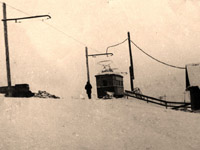
10. The ex-Leningrad car of the MS type near the Kolkhoznaya Stop. The car was transferred from the city of Prokopyevsk to Malyshev Log on a tractor trailer in late fall 1957. This is the only known photo of a tram on the Kaltan – Malyshev Log line. The photo is provided by the director of the Kaltan Muzey exhibition hall Aleksandr Ivanovich Fast. (Approximately 1958). |